One in a million Meridian
I remembered in one of our discussion in my classes in Masters regarding the contention of the 1st mass in the
 But in 1998, during the Philippine Centennial Commission Reading, a surprise came when the original logbook of the Magellan voyage was presented. There in the logbook was a complete log of coordinates of the voyage. And as it seems to put the issue to rest, the coordinates fit exactly at Limasawa! Problem solved…not.
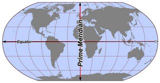
How can we be sure it was really Limasawa and not Masao? We forgot one thing that cartography is also in contention before…the Prime Meridian.
The Prime Meridian we know and use today is the Greenwich Prime Meridian. But during the Exploration Age, this is non-existent and in fact each European country had Prime Meridian different from one another. Perhaps the most famous of these Prime Meridians is the Paris Meridian. It was used in  foundation in 1667 up to 1914!
As a historian, we had to consider these small details especially regarding cartography since there are many maps and coordinates that are not creating in uniforms. The question now is, if we were to plot the said coordinates USING the Greenwich Meridian, this might not be the actual coordinates of the 1st mass in the
 For sure the Paris and the Greenwich Meridian is out of the question. The Paris Meridian will only come during the 1667 while the Greenwich Meridian will only be adapted in 1884. Was it the Seville Meridian? It is possible because
(Blogger’s note: Images are taken from www.wikipedia.org)


1 Comments:
Comprehensive study of Mazaua
I think you need to read the comprehensive study on the issue of Magellan's island-port that is published in the website of Dr. Vasco Caini, Italian nuclear scientist.
The URL is www.xeniaeditrice.it.
This article gives an exhaustive inventory of the properties of Mazaua.
You might also want to read the Wikipedia articles on the ff.:
1. Carlo Amoretti, father of the Limasawa hypothesis;
2. Gines de Mafra, the only seaman in Magellan's fleet to revisit Mazaua;
3. Jacques N. Bellin, the comprere of Voltaire and other Age of Enlightenment giants, whose map became the basis for the Limasawa hypothesis.
Vicente Calibo de Jesus
ginesdemafra@gmail.com
Post a Comment
<< Home